Our clients often ask us the difference between Boundary Surveys and ALTA/NSPS Land Surveys. Below are the questions we hear most often and some great insight from our survey team.
When do I use a Boundary Survey vs ALTA/NSPS Survey?
A Boundary Survey is primarily used to identify a piece of land’s corners and boundary lines. The information from a boundary survey can be used to resolve disputes between neighbors, erect fences or buildings, or understand property lines before purchasing a property.

ALTA/NSPS Surveys, named for the American Land Title Association and National Society of Professional Surveyors, are much more detailed and are typically used to support commercial real estate transactions. They are designed to satisfy the needs of lenders, corporations, and title companies for development, financing, and insuring title for the property.
While Boundary Surveys are often used on residential properties, they are also used on commercial properties but do not provide sufficient details to support title exams for insurance.
How do they differ in scope of work?
A Boundary Survey generally involves the determination and demarcation of property boundaries. It usually does not require the surveyor to identify other types of rights in real property, such as easements or encroachments.
Boundary surveys include field surveying of the property to measure and locate boundary lines, corners, and any existing encroachments. The survey will include taking precise measurements of the property and the location of all physical improvements on the land, such as buildings, fences, and roads.
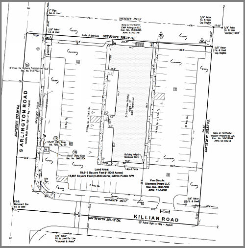
In contrast, an ALTA/NSPS Survey is much more detailed and includes a map of the property showing all improvements, easements, rights-of-way, and other elements impacting the ownership of the land. It will often include details about the buildings on the property, the location of utility lines, the presence of neighboring improvements, and more. Optional Table A items expand the scope of the ALTA/NSPS surveys to address the specific requirements of a transaction.
Do they adhere to the same Standards?
No. Boundary Surveys follow state and local standards, which can vary significantly, even from county to county, city to city, etc. An ALTA/NSPS Survey, on the other hand, adheres to the nationally recognized “Minimum Standard Detail Requirements for ALTA/NSPS Land Title Surveys.” These standards provide lenders, title companies, and buyers with a consistent, reliable survey product. The most current ALTA/NSPS Standard Requirements went into effect on February 23, 2021.
What kind of detail is provided in each report type?
As noted above, a Boundary Survey primarily concerns itself with the exact limits of the property. The professional surveyor uses various research methods and onsite field surveying and delivers a detailed map showing the property’s boundaries and features.
The ALTA/NSPS survey details the property lines and the location of all structures, roads, utilities, and other significant features on the property. It will also report on easements, rights-of-way, and other land use factors.
The ALTA/NSPS surveys also include a standardized set of optional “Table A” items that can be incorporated into the report. These items are typically used for commercial property transactions to provide more detail and assurance to the parties involved. They cover various aspects of the property, including encroachments, zoning issues, boundary evidence, and more. The inclusion of Table A items can vary based on the specific needs of the transaction and the property in question.
Summary
In summary, while both surveys provide essential information about a property, an ALTA/NSPS Land Survey is generally more detailed and adheres to nationally recognized standards, making it more appropriate for commercial transactions and development planning. Want to download a sample report or talk to an expert? Go here.
About CREtelligent.com. Commercial Real Estate Due Diligence. Simplified.
Gold River, CA-based CREtelligent opened its doors in 2015 as eScreenLogic, a Commercial Real Estate (CRE) environmental due diligence firm focused on desktop, RSRA, Phase I, and Phase II site assessments. In late 2020, eScreenLogic rebranded to CREtelligent to better reflect the company’s vision. Since then, the company has grown quickly and today provides the full spectrum of property due diligence services to commercial real estate professionals.
Media Contact: Gary Kulik | g.kulik@cretelligent.com


